


saillans

philou68
User
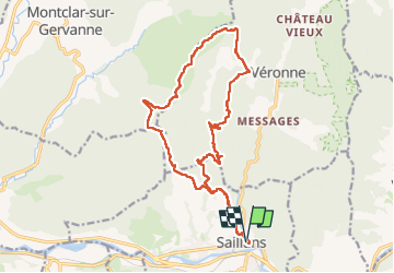

Length
19.1 km

Max alt
660 m

Uphill gradient
684 m
Km-Effort
28 km

Min alt
267 m

Downhill gradient
683 m
Boucle
Yes
Creation date :
2024-05-08 06:57:13.948
Updated on :
2024-05-12 09:34:20.772
7h20
Difficulty : Medium

FREE GPS app for hiking
 SityTrail
IGN / Geographical institutes
SityTrail Plus
The world is yours!
About
Trail Walking of 19.1 km to be discovered at Auvergne-Rhône-Alpes, Drôme, Saillans. This trail is proposed by philou68.
Description
la chapelle St Christophe
Positioning
Country:
France
Region :
Auvergne-Rhône-Alpes
Department/Province :
Drôme
Municipality :
Saillans
Location:
Unknown
Start:(Dec)
Start:(UTM)
674220 ; 4951727 (31T) N.
Comments