


ciere

dedejojo
User
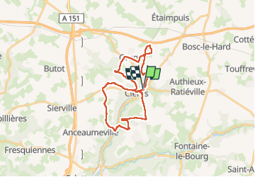

Length
26 km

Max alt
185 m

Uphill gradient
471 m
Km-Effort
32 km

Min alt
71 m

Downhill gradient
469 m
Boucle
Yes
Creation date :
2024-05-12 08:01:56.184
Updated on :
2024-05-12 14:10:52.149
5h45
Difficulty : Very difficult

FREE GPS app for hiking
 SityTrail
IGN / Geographical institutes
SityTrail Plus
The world is yours!
About
Trail Walking of 26 km to be discovered at Normandy, Seine-Maritime, Clères. This trail is proposed by dedejojo.
Positioning
Country:
France
Region :
Normandy
Department/Province :
Seine-Maritime
Municipality :
Clères
Location:
Unknown
Start:(Dec)
Start:(UTM)
363827 ; 5496051 (31U) N.
Comments