


GR5 - BLEGNY -> FRAIPONT

Ko-Rando
User
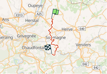

Length
22 km

Max alt
274 m

Uphill gradient
412 m
Km-Effort
28 km

Min alt
99 m

Downhill gradient
525 m
Boucle
No
Creation date :
2024-05-12 09:53:41.529
Updated on :
2024-05-12 14:35:51.128
4h22
Difficulty : Easy

FREE GPS app for hiking
 SityTrail
IGN / Geographical institutes
SityTrail Plus
The world is yours!
About
Trail Walking of 22 km to be discovered at Wallonia, Liège, Blegny. This trail is proposed by Ko-Rando.
Photos


Positioning
Country:
Belgium
Region :
Wallonia
Department/Province :
Liège
Municipality :
Blegny
Location:
Unknown
Start:(Dec)
Start:(UTM)
692263 ; 5616711 (31U) N.
Comments