


grt mdr

brandy
User
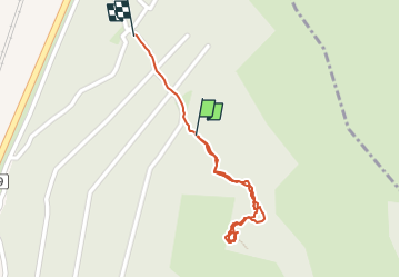

Length
806 m

Max alt
230 m

Uphill gradient
33 m
Km-Effort
1.3 km

Min alt
156 m

Downhill gradient
63 m
Boucle
Yes
Creation date :
2024-05-12 14:32:59.518
Updated on :
2024-05-12 15:28:18.265
21m
Difficulty : Easy

FREE GPS app for hiking
 SityTrail
IGN / Geographical institutes
SityTrail Plus
The world is yours!
About
Trail Walking of 806 m to be discovered at Auvergne-Rhône-Alpes, Drôme, Malataverne. This trail is proposed by brandy.
Positioning
Country:
France
Region :
Auvergne-Rhône-Alpes
Department/Province :
Drôme
Municipality :
Malataverne
Location:
Unknown
Start:(Dec)
Start:(UTM)
640813 ; 4925685 (31T) N.
Comments