


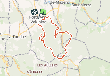
2024-05-13_14h29m45_GPX-FournatChatelard-PortesenValdaine

thonyc
User GUIDE

Length
15.3 km

Max alt
474 m

Uphill gradient
463 m
Km-Effort
21 km

Min alt
224 m

Downhill gradient
462 m
Boucle
Yes
Creation date :
2024-05-13 12:29:45.885
Updated on :
2024-09-30 15:07:09.099
4h52
Difficulty : Very difficult

FREE GPS app for hiking
 SityTrail
IGN / Geographical institutes
SityTrail Plus
The world is yours!
About
Trail Walking of 15.3 km to be discovered at Auvergne-Rhône-Alpes, Drôme, Portes-en-Valdaine. This trail is proposed by thonyc.
Positioning
Country:
France
Region :
Auvergne-Rhône-Alpes
Department/Province :
Drôme
Municipality :
Portes-en-Valdaine
Location:
Unknown
Start:(Dec)
Start:(UTM)
651893 ; 4932463 (31T) N.
Comments