


marville 16.05.2024

jcb48
User
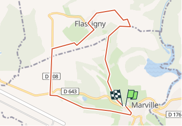

Length
8.8 km

Max alt
313 m

Uphill gradient
169 m
Km-Effort
11.1 km

Min alt
216 m

Downhill gradient
165 m
Boucle
Yes
Creation date :
2024-05-14 06:07:14.24
Updated on :
2024-05-14 06:08:26.385
2h30
Difficulty : Easy

FREE GPS app for hiking
 SityTrail
IGN / Geographical institutes
SityTrail Plus
The world is yours!
About
Trail On foot of 8.8 km to be discovered at Grand Est, Meuse, Marville. This trail is proposed by jcb48.
Description
randonnee
Positioning
Country:
France
Region :
Grand Est
Department/Province :
Meuse
Municipality :
Marville
Location:
Unknown
Start:(Dec)
Start:(UTM)
677747 ; 5480875 (31U) N.
Comments