


GR95 Die - Chatillon_Q3pE0

thonyc
User GUIDE
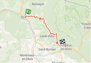

Length
19 km

Max alt
1162 m

Uphill gradient
1288 m
Km-Effort
36 km

Min alt
411 m

Downhill gradient
1112 m
Boucle
No
Creation date :
2024-05-14 07:05:26.262
Updated on :
2024-05-14 07:05:26.262

FREE GPS app for hiking
 SityTrail
IGN / Geographical institutes
SityTrail Plus
The world is yours!
About
Trail of 19 km to be discovered at Auvergne-Rhône-Alpes, Drôme, Die. This trail is proposed by thonyc.
Positioning
Country:
France
Region :
Auvergne-Rhône-Alpes
Department/Province :
Drôme
Municipality :
Die
Location:
Unknown
Start:(Dec)
Start:(UTM)
687871 ; 4958281 (31T) N.
Comments