


villette

luckyy
User
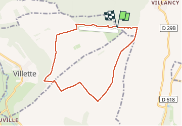

Length
7.4 km

Max alt
362 m

Uphill gradient
82 m
Km-Effort
8.5 km

Min alt
294 m

Downhill gradient
78 m
Boucle
Yes
Creation date :
2024-05-02 12:01:39.766
Updated on :
2024-05-14 10:10:36.08
2h19
Difficulty : Medium

FREE GPS app for hiking
 SityTrail
IGN / Geographical institutes
SityTrail Plus
The world is yours!
About
Trail Walking of 7.4 km to be discovered at Grand Est, Meurthe-et-Moselle, Villette. This trail is proposed by luckyy.
Positioning
Country:
France
Region :
Grand Est
Department/Province :
Meurthe-et-Moselle
Municipality :
Villette
Location:
Unknown
Start:(Dec)
Start:(UTM)
686736 ; 5484468 (31U) N.
Comments