


Saint Gengoux le National Le Moulin de Chatenay page58

grasgilbert
User
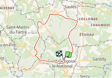

Length
14.5 km

Max alt
410 m

Uphill gradient
330 m
Km-Effort
18.9 km

Min alt
228 m

Downhill gradient
330 m
Boucle
Yes
Creation date :
2024-05-14 13:46:49.764
Updated on :
2024-05-14 13:50:53.74
4h18
Difficulty : Difficult

FREE GPS app for hiking
 SityTrail
IGN / Geographical institutes
SityTrail Plus
The world is yours!
About
Trail Walking of 14.5 km to be discovered at Bourgogne-Franche-Comté, Saône-et-Loire, Saint-Gengoux-le-National. This trail is proposed by grasgilbert.
Positioning
Country:
France
Region :
Bourgogne-Franche-Comté
Department/Province :
Saône-et-Loire
Municipality :
Saint-Gengoux-le-National
Location:
Unknown
Start:(Dec)
Start:(UTM)
627459 ; 5163726 (31T) N.
Comments