


Saint Point Les Montagnes page 72

grasgilbert
User
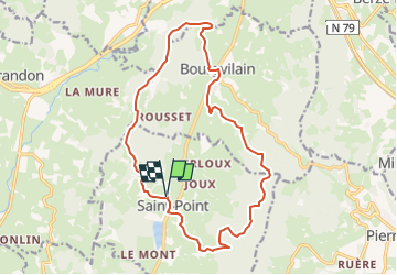

Length
17.2 km

Max alt
650 m

Uphill gradient
689 m
Km-Effort
26 km

Min alt
280 m

Downhill gradient
689 m
Boucle
Yes
Creation date :
2024-05-14 14:27:05.755
Updated on :
2024-05-15 09:05:13.274
5h59
Difficulty : Very difficult

FREE GPS app for hiking
 SityTrail
IGN / Geographical institutes
SityTrail Plus
The world is yours!
About
Trail Walking of 17.2 km to be discovered at Bourgogne-Franche-Comté, Saône-et-Loire, Saint-Point. This trail is proposed by grasgilbert.
Description
mangé sur les bancs à Bourvilain
Positioning
Country:
France
Region :
Bourgogne-Franche-Comté
Department/Province :
Saône-et-Loire
Municipality :
Saint-Point
Location:
Unknown
Start:(Dec)
Start:(UTM)
624307 ; 5133349 (31T) N.
Comments