


monteynard (la ville) - le majeil

maupassant38
User
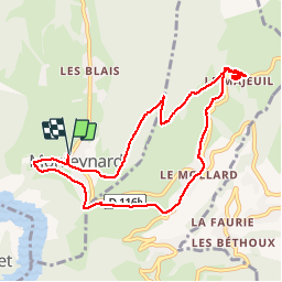

Length
9.4 km

Max alt
1177 m

Uphill gradient
477 m
Km-Effort
15.8 km

Min alt
775 m

Downhill gradient
476 m
Boucle
Yes
Creation date :
2019-02-22 22:31:45.624
Updated on :
2019-02-22 22:31:45.64
3h02
Difficulty : Medium

FREE GPS app for hiking
 SityTrail
IGN / Geographical institutes
SityTrail Plus
The world is yours!
About
Trail Walking of 9.4 km to be discovered at Auvergne-Rhône-Alpes, Isère, Monteynard. This trail is proposed by maupassant38.
Positioning
Country:
France
Region :
Auvergne-Rhône-Alpes
Department/Province :
Isère
Municipality :
Monteynard
Location:
Unknown
Start:(Dec)
Start:(UTM)
712992 ; 4982765 (31T) N.
Comments