


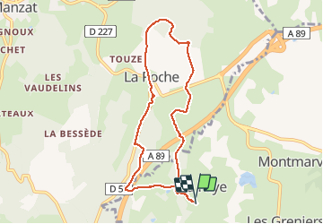
La Faye haute-La Roche

Gegetop
User

Length
7.9 km

Max alt
827 m

Uphill gradient
192 m
Km-Effort
10.5 km

Min alt
722 m

Downhill gradient
197 m
Boucle
Yes
Creation date :
2015-07-16 00:00:00.0
Updated on :
2015-07-16 00:00:00.0
2h14
Difficulty : Easy

FREE GPS app for hiking
 SityTrail
IGN / Geographical institutes
SityTrail Plus
The world is yours!
About
Trail Walking of 7.9 km to be discovered at Auvergne-Rhône-Alpes, Puy-de-Dôme, Loubeyrat. This trail is proposed by Gegetop.
Description
Circuit agréable.
A Bacana vous n'êtes pas obligé de couper à travers bois vous rejoindrez la passerelle qui enjambe l'autoroute en continuant sur la route environ 200m.
Positioning
Country:
France
Region :
Auvergne-Rhône-Alpes
Department/Province :
Puy-de-Dôme
Municipality :
Loubeyrat
Location:
Unknown
Start:(Dec)
Start:(UTM)
498094 ; 5086873 (31T) N.
Comments