


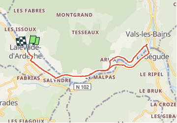
balade voie verte lalevad

raab
User

Length
8.9 km

Max alt
275 m

Uphill gradient
106 m
Km-Effort
10.3 km

Min alt
232 m

Downhill gradient
105 m
Boucle
Yes
Creation date :
2024-05-17 11:46:29.95
Updated on :
2024-05-17 14:27:27.334
2h40
Difficulty : Medium

FREE GPS app for hiking
 SityTrail
IGN / Geographical institutes
SityTrail Plus
The world is yours!
About
Trail Walking of 8.9 km to be discovered at Auvergne-Rhône-Alpes, Ardèche, Lalevade-d'Ardèche. This trail is proposed by raab.
Positioning
Country:
France
Region :
Auvergne-Rhône-Alpes
Department/Province :
Ardèche
Municipality :
Lalevade-d'Ardèche
Location:
Unknown
Start:(Dec)
Start:(UTM)
604945 ; 4945033 (31T) N.
Comments