


Tour_Cret_Arjoux_12_0

d.rognon
User
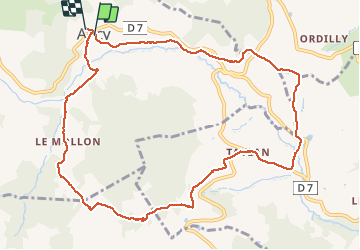

Length
12 km

Max alt
723 m

Uphill gradient
441 m
Km-Effort
17.9 km

Min alt
383 m

Downhill gradient
434 m
Boucle
Yes
Creation date :
2016-03-25 00:00:00.0
Updated on :
2016-03-25 00:00:00.0
3h19
Difficulty : Unknown

FREE GPS app for hiking
 SityTrail
IGN / Geographical institutes
SityTrail Plus
The world is yours!
About
Trail Walking of 12 km to be discovered at Auvergne-Rhône-Alpes, Rhône, Ancy. This trail is proposed by d.rognon.
Positioning
Country:
France
Region :
Auvergne-Rhône-Alpes
Department/Province :
Rhône
Municipality :
Ancy
Location:
Unknown
Start:(Dec)
Start:(UTM)
617194 ; 5077117 (31T) N.
Comments