


Clecy

Dupuybadonniere
User
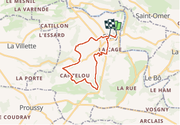

Length
11.2 km

Max alt
208 m

Uphill gradient
351 m
Km-Effort
15.9 km

Min alt
47 m

Downhill gradient
352 m
Boucle
No
Creation date :
2024-05-18 07:25:09.897
Updated on :
2024-05-18 11:09:19.306
3h07
Difficulty : Difficult

FREE GPS app for hiking
 SityTrail
IGN / Geographical institutes
SityTrail Plus
The world is yours!
About
Trail Walking of 11.2 km to be discovered at Normandy, Calvados, Clécy. This trail is proposed by Dupuybadonniere.
Positioning
Country:
France
Region :
Normandy
Department/Province :
Calvados
Municipality :
Clécy
Location:
Unknown
Start:(Dec)
Start:(UTM)
684409 ; 5421156 (30U) N.
Comments