


Le puy de tressou

jeanic63
User

Length
3.5 km

Max alt
960 m

Uphill gradient
101 m
Km-Effort
4.8 km

Min alt
864 m

Downhill gradient
101 m
Boucle
Yes
Creation date :
2024-05-19 07:59:43.253
Updated on :
2024-05-19 09:01:06.241
1h00
Difficulty : Easy

FREE GPS app for hiking
 SityTrail
IGN / Geographical institutes
SityTrail Plus
The world is yours!
About
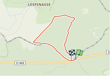
Trail Walking of 3.5 km to be discovered at Auvergne-Rhône-Alpes, Puy-de-Dôme, Saint-Ours. This trail is proposed by jeanic63.
Description
Le puy de trésor vers le cratère, départ parking en face de l'entrée de la carrière sur D 943
Positioning
Country:
France
Region :
Auvergne-Rhône-Alpes
Department/Province :
Puy-de-Dôme
Municipality :
Saint-Ours
Location:
Unknown
Start:(Dec)
Start:(UTM)
496216 ; 5078444 (31T) N.
Comments