


R2-jg1-nuit

Jack-94
User

Length
12.1 km

Max alt
153 m

Uphill gradient
250 m
Km-Effort
15.4 km

Min alt
86 m

Downhill gradient
248 m
Boucle
Yes
Creation date :
2024-05-20 08:58:24.025
Updated on :
2024-05-20 12:53:55.618
3h29
Difficulty : Difficult

FREE GPS app for hiking
 SityTrail
IGN / Geographical institutes
SityTrail Plus
The world is yours!
About
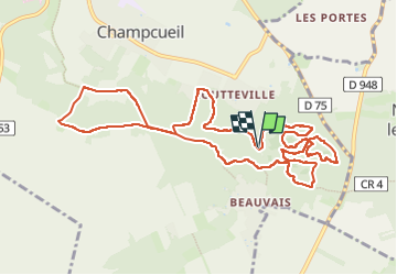
Trail Walking of 12.1 km to be discovered at Ile-de-France, Essonne, Champcueil. This trail is proposed by Jack-94.
Positioning
Country:
France
Region :
Ile-de-France
Department/Province :
Essonne
Municipality :
Champcueil
Location:
Unknown
Start:(Dec)
Start:(UTM)
460733 ; 5372331 (31U) N.
Comments