


Morzine

raygautier
User
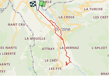

Length
7.3 km

Max alt
1085 m

Uphill gradient
161 m
Km-Effort
9.4 km

Min alt
947 m

Downhill gradient
161 m
Boucle
Yes
Creation date :
2024-05-20 08:12:52.0
Updated on :
2024-05-20 10:12:34.131

FREE GPS app for hiking
 SityTrail
IGN / Geographical institutes
SityTrail Plus
The world is yours!
About
Trail of 7.3 km to be discovered at Auvergne-Rhône-Alpes, Upper Savoy, Morzine. This trail is proposed by raygautier.
Positioning
Country:
France
Region :
Auvergne-Rhône-Alpes
Department/Province :
Upper Savoy
Municipality :
Morzine
Location:
Unknown
Start:(Dec)
Start:(UTM)
322177 ; 5117440 (32T) N.
Comments