


Les rochers de Roques Altes

franquen
User
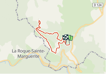

Length
6.9 km

Max alt
851 m

Uphill gradient
266 m
Km-Effort
10.5 km

Min alt
625 m

Downhill gradient
274 m
Boucle
Yes
Creation date :
2024-05-21 09:04:02.454
Updated on :
2024-05-22 05:20:07.585
2h23
Difficulty : Medium

FREE GPS app for hiking
 SityTrail
IGN / Geographical institutes
SityTrail Plus
The world is yours!
About
Trail Walking of 6.9 km to be discovered at Occitania, Aveyron, Saint-André-de-Vézines. This trail is proposed by franquen.
Description
boucle en partant de Montmèjean
Positioning
Country:
France
Region :
Occitania
Department/Province :
Aveyron
Municipality :
Saint-André-de-Vézines
Location:
Unknown
Start:(Dec)
Start:(UTM)
519596 ; 4886192 (31T) N.
Comments