


Dombasle_13 km _2024_Formation

ZAMBAUX
User
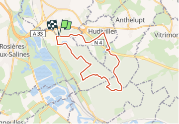

Length
13.3 km

Max alt
264 m

Uphill gradient
122 m
Km-Effort
14.9 km

Min alt
222 m

Downhill gradient
122 m
Boucle
Yes
Creation date :
2024-05-22 06:13:28.453
Updated on :
2024-05-22 06:15:16.622
3h23
Difficulty : Difficult

FREE GPS app for hiking
 SityTrail
IGN / Geographical institutes
SityTrail Plus
The world is yours!
About
Trail Walking of 13.3 km to be discovered at Grand Est, Meurthe-et-Moselle, Dombasle-sur-Meurthe. This trail is proposed by ZAMBAUX.
Description
Marche en forêt
Positioning
Country:
France
Region :
Grand Est
Department/Province :
Meurthe-et-Moselle
Municipality :
Dombasle-sur-Meurthe
Location:
Unknown
Start:(Dec)
Start:(UTM)
305747 ; 5386436 (32U) N.
Comments
un peu trop d'eau