


Crest

raygautier
User
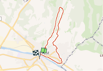

Length
7.8 km

Max alt
404 m

Uphill gradient
251 m
Km-Effort
11.1 km

Min alt
185 m

Downhill gradient
250 m
Boucle
Yes
Creation date :
2024-05-23 06:02:12.0
Updated on :
2024-05-23 10:07:47.526

FREE GPS app for hiking
 SityTrail
IGN / Geographical institutes
SityTrail Plus
The world is yours!
About
Trail of 7.8 km to be discovered at Auvergne-Rhône-Alpes, Drôme, Crest. This trail is proposed by raygautier.
Positioning
Country:
France
Region :
Auvergne-Rhône-Alpes
Department/Province :
Drôme
Municipality :
Crest
Location:
Unknown
Start:(Dec)
Start:(UTM)
660047 ; 4954547 (31T) N.
Comments