


Autun E2

pascal.dabet
User

Length
17.8 km

Max alt
815 m

Uphill gradient
661 m
Km-Effort
27 km

Min alt
427 m

Downhill gradient
661 m
Boucle
Yes
Creation date :
2022-06-11 07:42:54.835
Updated on :
2024-05-24 15:20:09.551
5h57
Difficulty : Very difficult

FREE GPS app for hiking
 SityTrail
IGN / Geographical institutes
SityTrail Plus
The world is yours!
About
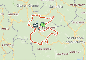
Trail Walking of 17.8 km to be discovered at Bourgogne-Franche-Comté, Saône-et-Loire, Saint-Léger-sous-Beuvray. This trail is proposed by pascal.dabet.
Positioning
Country:
France
Region :
Bourgogne-Franche-Comté
Department/Province :
Saône-et-Loire
Municipality :
Saint-Léger-sous-Beuvray
Location:
Unknown
Start:(Dec)
Start:(UTM)
579864 ; 5198157 (31T) N.
Comments