


lac de monteynard - pont de brion

maupassant38
User
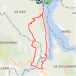

Length
8.2 km

Max alt
822 m

Uphill gradient
495 m
Km-Effort
14.8 km

Min alt
487 m

Downhill gradient
496 m
Boucle
Yes
Creation date :
2019-02-22 22:31:45.229
Updated on :
2019-02-22 22:31:45.258
3h47
Difficulty : Medium

FREE GPS app for hiking
 SityTrail
IGN / Geographical institutes
SityTrail Plus
The world is yours!
About
Trail Walking of 8.2 km to be discovered at Auvergne-Rhône-Alpes, Isère, Treffort. This trail is proposed by maupassant38.
Positioning
Country:
France
Region :
Auvergne-Rhône-Alpes
Department/Province :
Isère
Municipality :
Treffort
Location:
Unknown
Start:(Dec)
Start:(UTM)
711227 ; 4974490 (31T) N.
Comments