


Boucle sur les hauteurs de Coublevie - 26 mai 2024

morganee
User
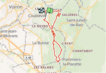

Length
16.7 km

Max alt
941 m

Uphill gradient
711 m
Km-Effort
26 km

Min alt
404 m

Downhill gradient
707 m
Boucle
Yes
Creation date :
2024-05-26 10:09:36.265
Updated on :
2024-05-26 16:35:43.509
5h25
Difficulty : Easy

FREE GPS app for hiking
 SityTrail
IGN / Geographical institutes
SityTrail Plus
The world is yours!
About
Trail Walking of 16.7 km to be discovered at Auvergne-Rhône-Alpes, Isère, Coublevie. This trail is proposed by morganee.
Positioning
Country:
France
Region :
Auvergne-Rhône-Alpes
Department/Province :
Isère
Municipality :
Coublevie
Location:
Unknown
Start:(Dec)
Start:(UTM)
705727 ; 5025681 (31T) N.
Comments