


HAMOIR-FAIRON et retour

Michel GUISSE
User
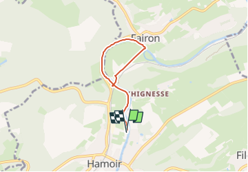

Length
4.6 km

Max alt
132 m

Uphill gradient
42 m
Km-Effort
5.1 km

Min alt
105 m

Downhill gradient
42 m
Boucle
Yes
Creation date :
2024-05-27 07:07:14.691
Updated on :
2024-05-27 07:09:25.306
1h09
Difficulty : Easy

FREE GPS app for hiking
 SityTrail
IGN / Geographical institutes
SityTrail Plus
The world is yours!
About
Trail Walking of 4.6 km to be discovered at Wallonia, Liège, Hamoir. This trail is proposed by Michel GUISSE.
Description
promenade facile,à plat le long de l'Ourthe
Positioning
Country:
Belgium
Region :
Wallonia
Department/Province :
Liège
Municipality :
Hamoir
Location:
Unknown
Start:(Dec)
Start:(UTM)
680270 ; 5589575 (31U) N.
Comments