


Pierrette

tine60
User
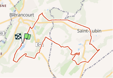

Length
12 km

Max alt
135 m

Uphill gradient
168 m
Km-Effort
14.2 km

Min alt
60 m

Downhill gradient
168 m
Boucle
Yes
Creation date :
2024-05-28 07:18:11.0
Updated on :
2024-05-28 10:40:18.386

FREE GPS app for hiking
 SityTrail
IGN / Geographical institutes
SityTrail Plus
The world is yours!
About
Trail of 12 km to be discovered at Hauts-de-France, Aisne, Blérancourt. This trail is proposed by tine60.
Positioning
Country:
France
Region :
Hauts-de-France
Department/Province :
Aisne
Municipality :
Blérancourt
Location:
Unknown
Start:(Dec)
Start:(UTM)
511047 ; 5483810 (31U) N.
Comments