Trail Walking Decazeville - St Jacques étape 12 - Photo

St Jacques étape 12

© OpenStreetMap contributors
Length
Length
29 km
Max alt
Max alt
422 m
Uphill gradient
Uphill gradient
739 m
Km-Effort
Km-Effort  
39 km
Min alt
Min alt
177 m
Downhill gradient
Downhill gradient
551 m
Boucle
Boucle
No
Creation date :
2016-03-09 00:00:00.0
Updated on :
2016-03-09 00:00:00.0

(1 Reviews)

Walking
Walking
9h31
Difficulty : Very easy

Scan this QR Code to open this trail in the SityTrail application

FREE GPS app for hiking

Logo SityTrail SityTrail

IGN / Geographical institutes

Download SityTrail from the App Store Download SityTrail from Google Play

Logo SityTrail SityTrail World

The world is yours!

Download SityTrail from the App Store Download SityTrail from Google Play Download SityTrail on Huawei AppGallery

About

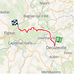
Trail Walking of 29 km to be discovered at Occitania, Aveyron, Decazeville. This trail is proposed by Jean-MarieFaux.

Description

Decazeville - Seyrignac près Figeac.               Après une rude montée à Saint Roch et une descente nerveuse sur Livinhiac le haut, on accède à la route de crête de MontRedon, puis on passe par Saint Félix et St jean Mirabel avant de quitter le GR pour Seyrignac ou se trouve deux gites d'étape à trois Km de Figeac étape de 25 km

Elevation profile

Positioning

Country:
France
Region :
Occitania
Department/Province :
Aveyron
Municipality :
Decazeville
Location:
Unknown
Start:(UTM)
440190 ; 4934715 (31T) N.

Comments

Please log in to post a review or rate the element


Trails nearby

Trail Other activity Decazeville - compostelle 2017 mt - Photo
Other activity
MAITHE

Other activity

Very easy
(5)
Decazeville, Occitania, Aveyron, France
214 km | 295 km-effort
1666h 40min
No
Trail Walking Livinhac-le-Haut - Livinhac le Haut - Figeac - Chemin de St-Jacques de Compostelle - Photo
Walking
tracegps

Walking

Very difficult
(4)
Livinhac-le-Haut, Occitania, Aveyron, France
26 km | 33 km-effort
5h 0min
No
Trail On foot Decazeville - Les découvertes - Photo
On foot
PRO

On foot

Easy
Decazeville, Occitania, Aveyron, France
12.3 km | 18.3 km-effort
4h 9min
No
Trail On foot Aubin - Les crêtes de Combes - Photo
On foot
PRO

On foot

Easy
Aubin, Occitania, Aveyron, France
6.9 km | 9.6 km-effort
2h 10min
Yes
Trail On foot Decazeville - Entre plateau et découverte - Photo
On foot
PRO

On foot

Easy
Decazeville, Occitania, Aveyron, France
11.6 km | 17.1 km-effort
3h 53min
Yes
Trail On foot Aubin - Entre Deux Vallées - Photo
On foot
PRO

On foot

Easy
Aubin, Occitania, Aveyron, France
8.6 km | 11.5 km-effort
2h 36min
Yes
Trail On foot Decazeville - Le panoramique - Photo
On foot
PRO

On foot

Easy
Decazeville, Occitania, Aveyron, France
4.3 km | 6.8 km-effort
1h 32min
Yes
Trail On foot Aubin - Petit tour de la vaysse - Photo
On foot
PRO

On foot

Easy
Aubin, Occitania, Aveyron, France
3.8 km | 5.5 km-effort
1h 14min
Yes
Trail On foot Cransac - Les surprises de la Vaysse - Photo
On foot
PRO

On foot

Easy
Cransac, Occitania, Aveyron, France
6 km | 8.3 km-effort
1h 52min
Yes


Close
My subscriptions