


Cenves Le Col du Carcan Grange du Bois page 78

grasgilbert
User
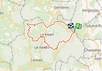

Length
14.9 km

Max alt
712 m

Uphill gradient
680 m
Km-Effort
24 km

Min alt
342 m

Downhill gradient
687 m
Boucle
Yes
Creation date :
2024-05-29 08:23:18.767
Updated on :
2024-05-29 09:12:25.866
5h26
Difficulty : Very difficult

FREE GPS app for hiking
 SityTrail
IGN / Geographical institutes
SityTrail Plus
The world is yours!
About
Trail Walking of 14.9 km to be discovered at Auvergne-Rhône-Alpes, Rhône, Cenves. This trail is proposed by grasgilbert.
Positioning
Country:
France
Region :
Auvergne-Rhône-Alpes
Department/Province :
Rhône
Municipality :
Cenves
Location:
Unknown
Start:(Dec)
Start:(UTM)
630707 ; 5127804 (31T) N.
Comments