


Porquerolles_290524_7_2

d.rognon
User
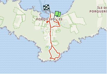

Length
7.2 km

Max alt
57 m

Uphill gradient
89 m
Km-Effort
8.5 km

Min alt
0 m

Downhill gradient
111 m
Boucle
No
Creation date :
2024-05-29 08:13:55.038
Updated on :
2024-05-29 13:12:20.419
4h57
Difficulty : Very easy

FREE GPS app for hiking
 SityTrail
IGN / Geographical institutes
SityTrail Plus
The world is yours!
About
Trail Walking of 7.2 km to be discovered at Provence-Alpes-Côte d'Azur, Var, Hyères. This trail is proposed by d.rognon.
Positioning
Country:
France
Region :
Provence-Alpes-Côte d'Azur
Department/Province :
Var
Municipality :
Hyères
Location:
Unknown
Start:(Dec)
Start:(UTM)
272161 ; 4764568 (32T) N.
Comments