


30 mai 2024

c.chehere
User

Length
3.8 km

Max alt
98 m

Uphill gradient
48 m
Km-Effort
4.5 km

Min alt
53 m

Downhill gradient
50 m
Boucle
Yes
Creation date :
2024-05-30 06:27:16.526
Updated on :
2024-05-30 07:27:44.679
58m
Difficulty : Easy

FREE GPS app for hiking
 SityTrail
IGN / Geographical institutes
SityTrail Plus
The world is yours!
About
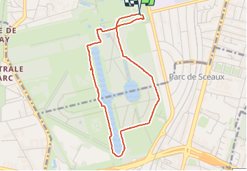
Trail Walking of 3.8 km to be discovered at Ile-de-France, Hauts-de-Seine, Sceaux. This trail is proposed by c.chehere.
Positioning
Country:
France
Region :
Ile-de-France
Department/Province :
Hauts-de-Seine
Municipality :
Sceaux
Location:
Unknown
Start:(Dec)
Start:(UTM)
448786 ; 5402661 (31U) N.
Comments