


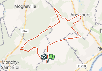
Villers-Saint-Paul_La Croix Méfroid_Trace GPS simplifiée10,3 km

Pousscailleux
User

Length
10.2 km

Max alt
115 m

Uphill gradient
158 m
Km-Effort
12.3 km

Min alt
43 m

Downhill gradient
158 m
Boucle
Yes
Creation date :
2015-04-13 00:00:00.0
Updated on :
2015-04-13 00:00:00.0
2h43
Difficulty : Medium

FREE GPS app for hiking
 SityTrail
IGN / Geographical institutes
SityTrail Plus
The world is yours!
About
Trail Walking of 10.2 km to be discovered at Hauts-de-France, Oise, Villers-Saint-Paul. This trail is proposed by Pousscailleux.
Description
Départ du Parking du Caravaning de Villers, (17)rue Charles Notaire. Coordonnées : N49°17'33.81" / E002°29'07.21"
Positioning
Country:
France
Region :
Hauts-de-France
Department/Province :
Oise
Municipality :
Villers-Saint-Paul
Location:
Unknown
Start:(Dec)
Start:(UTM)
462590 ; 5460124 (31U) N.
Comments