


Sans douci

raygautier
User
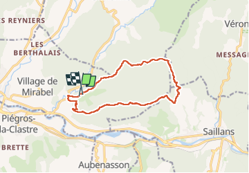

Length
13 km

Max alt
670 m

Uphill gradient
567 m
Km-Effort
21 km

Min alt
257 m

Downhill gradient
550 m
Boucle
Yes
Creation date :
2024-05-30 10:48:59.0
Updated on :
2024-05-30 15:01:57.312

FREE GPS app for hiking
 SityTrail
IGN / Geographical institutes
SityTrail Plus
The world is yours!
About
Trail of 13 km to be discovered at Auvergne-Rhône-Alpes, Drôme, Mirabel-et-Blacons. This trail is proposed by raygautier.
Positioning
Country:
France
Region :
Auvergne-Rhône-Alpes
Department/Province :
Drôme
Municipality :
Mirabel-et-Blacons
Location:
Unknown
Start:(Dec)
Start:(UTM)
668577 ; 4952948 (31T) N.
Comments