


2024 06 01 Saulges circuit 33

chlafaille
User
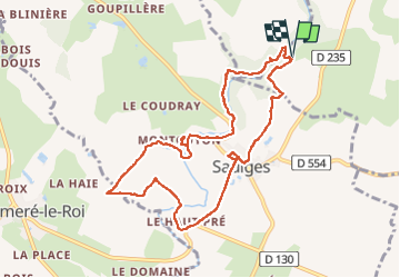

Length
9.4 km

Max alt
102 m

Uphill gradient
133 m
Km-Effort
11.1 km

Min alt
52 m

Downhill gradient
132 m
Boucle
Yes
Creation date :
2024-06-01 08:17:41.435
Updated on :
2024-06-01 10:28:11.735
2h10
Difficulty : Easy

FREE GPS app for hiking
 SityTrail
IGN / Geographical institutes
SityTrail Plus
The world is yours!
About
Trail Walking of 9.4 km to be discovered at Pays de la Loire, Mayenne, Thorigné-en-Charnie. This trail is proposed by chlafaille.
Positioning
Country:
France
Region :
Pays de la Loire
Department/Province :
Mayenne
Municipality :
Thorigné-en-Charnie
Location:
Unknown
Start:(Dec)
Start:(UTM)
694031 ; 5318890 (30T) N.
Comments