


,Narcisses

Jean-Paulchoux
User
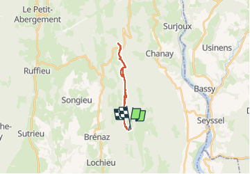

Length
17.2 km

Max alt
1268 m

Uphill gradient
532 m
Km-Effort
24 km

Min alt
966 m

Downhill gradient
551 m
Boucle
No
Creation date :
2024-06-01 07:02:19.172
Updated on :
2024-06-01 14:31:24.098
4h23
Difficulty : Medium

FREE GPS app for hiking
 SityTrail
IGN / Geographical institutes
SityTrail Plus
The world is yours!
About
Trail Walking of 17.2 km to be discovered at Auvergne-Rhône-Alpes, Ain, Arvière-en-Valromey. This trail is proposed by Jean-Paulchoux.
Positioning
Country:
France
Region :
Auvergne-Rhône-Alpes
Department/Province :
Ain
Municipality :
Arvière-en-Valromey
Location:
Brénaz
Start:(Dec)
Start:(UTM)
713534 ; 5092406 (31T) N.
Comments