


tour des fontaines salées au deprt de Chareire

CABERMAT
User
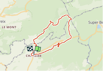

Length
16.1 km

Max alt
1644 m

Uphill gradient
588 m
Km-Effort
24 km

Min alt
1163 m

Downhill gradient
590 m
Boucle
Yes
Creation date :
2024-06-02 07:41:50.043
Updated on :
2024-06-02 14:09:44.968
6h25
Difficulty : Very difficult

FREE GPS app for hiking
 SityTrail
IGN / Geographical institutes
SityTrail Plus
The world is yours!
About
Trail Walking of 16.1 km to be discovered at Auvergne-Rhône-Alpes, Puy-de-Dôme, Picherande. This trail is proposed by CABERMAT.
Positioning
Country:
France
Region :
Auvergne-Rhône-Alpes
Department/Province :
Puy-de-Dôme
Municipality :
Picherande
Location:
Unknown
Start:(Dec)
Start:(UTM)
482662 ; 5036685 (31T) N.
Comments