


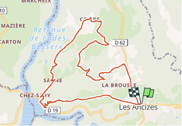
les ancizes comps - La Chartreuse 19km

jeanic63
User

Length
19.3 km

Max alt
708 m

Uphill gradient
575 m
Km-Effort
27 km

Min alt
511 m

Downhill gradient
573 m
Boucle
Yes
Creation date :
2024-06-03 06:19:24.764
Updated on :
2025-01-12 18:10:39.689
6h07
Difficulty : Very difficult

FREE GPS app for hiking
 SityTrail
IGN / Geographical institutes
SityTrail Plus
The world is yours!
About
Trail Walking of 19.3 km to be discovered at Auvergne-Rhône-Alpes, Puy-de-Dôme, Les Ancizes-Comps. This trail is proposed by jeanic63.
Description
départ les ancizes parking de la mairie
Positioning
Country:
France
Region :
Auvergne-Rhône-Alpes
Department/Province :
Puy-de-Dôme
Municipality :
Les Ancizes-Comps
Location:
Unknown
Start:(Dec)
Start:(UTM)
485201 ; 5085815 (31T) N.
Comments