


og-60

Jack-94
User
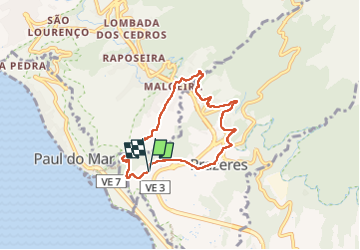

Length
7.7 km

Max alt
673 m

Uphill gradient
351 m
Km-Effort
12.4 km

Min alt
368 m

Downhill gradient
341 m
Boucle
Yes
Creation date :
2024-06-03 09:03:35.544
Updated on :
2024-06-03 13:35:57.878
4h31
Difficulty : Difficult

FREE GPS app for hiking
 SityTrail
IGN / Geographical institutes
SityTrail Plus
The world is yours!
About
Trail Walking of 7.7 km to be discovered at Madeira, Unknown, Prazeres. This trail is proposed by Jack-94.
Positioning
Country:
Portugal
Region :
Madeira
Department/Province :
Unknown
Municipality :
Prazeres
Location:
Unknown
Start:(Dec)
Start:(UTM)
292563 ; 3626059 (28S) N.
Comments