


Mionnay-37km-302m

ThierryJ01
User
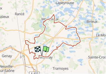

Length
37 km

Max alt
310 m

Uphill gradient
303 m
Km-Effort
41 km

Min alt
274 m

Downhill gradient
302 m
Boucle
Yes
Creation date :
2024-06-03 21:12:49.731
Updated on :
2024-06-03 21:13:54.609
2h48
Difficulty : Difficult

FREE GPS app for hiking
 SityTrail
IGN / Geographical institutes
SityTrail Plus
The world is yours!
About
Trail Mountain bike of 37 km to be discovered at Auvergne-Rhône-Alpes, Ain, Mionnay. This trail is proposed by ThierryJ01.
Positioning
Country:
France
Region :
Auvergne-Rhône-Alpes
Department/Province :
Ain
Municipality :
Mionnay
Location:
Unknown
Start:(Dec)
Start:(UTM)
649154 ; 5084431 (31T) N.
Comments