


saint Étienne vallée francaise

labarone
User
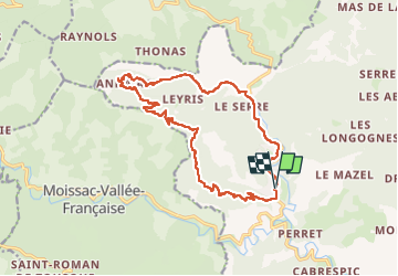

Length
18.3 km

Max alt
669 m

Uphill gradient
548 m
Km-Effort
26 km

Min alt
246 m

Downhill gradient
546 m
Boucle
Yes
Creation date :
2024-06-04 07:09:35.306
Updated on :
2024-06-04 13:21:43.115
5h35
Difficulty : Easy

FREE GPS app for hiking
 SityTrail
IGN / Geographical institutes
SityTrail Plus
The world is yours!
About
Trail Walking of 18.3 km to be discovered at Occitania, Lozère, Saint-Étienne-Vallée-Française. This trail is proposed by labarone.
Description
cool
Photos

Positioning
Country:
France
Region :
Occitania
Department/Province :
Lozère
Municipality :
Saint-Étienne-Vallée-Française
Location:
Unknown
Start:(Dec)
Start:(UTM)
567303 ; 4890624 (31T) N.
Comments