


SityTrail - 2023-10-05_09h12m35_venntrilogie-telecharger-fichier-gpx

guy284
User
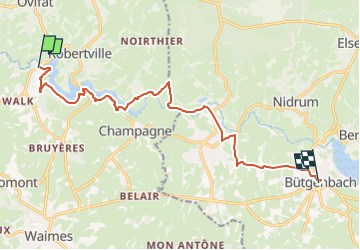

Length
11.9 km

Max alt
590 m

Uphill gradient
262 m
Km-Effort
15.2 km

Min alt
498 m

Downhill gradient
191 m
Boucle
No
Creation date :
2024-06-04 19:54:03.041
Updated on :
2024-06-19 11:50:43.242
3h26
Difficulty : Difficult

FREE GPS app for hiking
 SityTrail
IGN / Geographical institutes
SityTrail Plus
The world is yours!
About
Trail Walking of 11.9 km to be discovered at Wallonia, Liège, Waimes. This trail is proposed by guy284.
Positioning
Country:
Belgium
Region :
Wallonia
Department/Province :
Liège
Municipality :
Waimes
Location:
Unknown
Start:(Dec)
Start:(UTM)
294726 ; 5592877 (32U) N.
Comments