


2024-06-04_21h59m24_rouge

Pascalchris
User
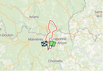

Length
33 km

Max alt
1082 m

Uphill gradient
607 m
Km-Effort
41 km

Min alt
911 m

Downhill gradient
609 m
Boucle
Yes
Creation date :
2024-06-04 19:59:24.4
Updated on :
2025-05-31 19:56:43.309
0m
Difficulty : Very easy

FREE GPS app for hiking
 SityTrail
IGN / Geographical institutes
SityTrail Plus
The world is yours!
About
Trail Equestrian of 33 km to be discovered at Auvergne-Rhône-Alpes, Haute-Loire, Jullianges. This trail is proposed by Pascalchris.
Positioning
Country:
France
Region :
Auvergne-Rhône-Alpes
Department/Province :
Haute-Loire
Municipality :
Jullianges
Location:
Unknown
Start:(Dec)
Start:(UTM)
562221 ; 5016624 (31T) N.
Comments