


2024-06-04_22h01m22_jaune1

Pascalchris
User
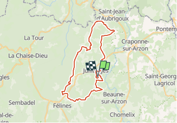

Length
31 km

Max alt
1084 m

Uphill gradient
631 m
Km-Effort
40 km

Min alt
914 m

Downhill gradient
632 m
Boucle
Yes
Creation date :
2024-06-04 20:01:22.616
Updated on :
2024-06-04 20:01:23.634

FREE GPS app for hiking
 SityTrail
IGN / Geographical institutes
SityTrail Plus
The world is yours!
About
Trail of 31 km to be discovered at Auvergne-Rhône-Alpes, Haute-Loire, Jullianges. This trail is proposed by Pascalchris.
Positioning
Country:
France
Region :
Auvergne-Rhône-Alpes
Department/Province :
Haute-Loire
Municipality :
Jullianges
Location:
Unknown
Start:(Dec)
Start:(UTM)
562230 ; 5016594 (31T) N.
Comments