


Tence Le Mezenc 85km 1600m

thonyc
User GUIDE
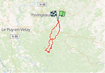

Length
85 km

Max alt
1571 m

Uphill gradient
1739 m
Km-Effort
108 km

Min alt
842 m

Downhill gradient
1736 m
Boucle
Yes
Creation date :
2024-05-23 06:44:19.312
Updated on :
2024-06-05 07:04:43.207
6h22
Difficulty : Medium

FREE GPS app for hiking
 SityTrail
IGN / Geographical institutes
SityTrail Plus
The world is yours!
About
Trail Road bike of 85 km to be discovered at Auvergne-Rhône-Alpes, Haute-Loire, Tence. This trail is proposed by thonyc.
Positioning
Country:
France
Region :
Auvergne-Rhône-Alpes
Department/Province :
Haute-Loire
Municipality :
Tence
Location:
Unknown
Start:(Dec)
Start:(UTM)
600879 ; 4995598 (31T) N.
Comments