


Rando chêne d'Antin - Bord de Seine - 9 km

jeanmarcMasson
User GUIDE
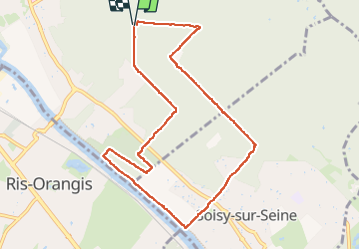

Length
9.2 km

Max alt
96 m

Uphill gradient
102 m
Km-Effort
10.5 km

Min alt
29 m

Downhill gradient
100 m
Boucle
Yes
Creation date :
2024-06-05 12:02:11.023
Updated on :
2024-06-05 15:03:20.719
2h18
Difficulty : Medium

FREE GPS app for hiking
 SityTrail
IGN / Geographical institutes
SityTrail Plus
The world is yours!
About
Trail Walking of 9.2 km to be discovered at Ile-de-France, Essonne, Draveil. This trail is proposed by jeanmarcMasson.
Positioning
Country:
France
Region :
Ile-de-France
Department/Province :
Essonne
Municipality :
Draveil
Location:
Unknown
Start:(Dec)
Start:(UTM)
458025 ; 5391148 (31U) N.
Comments