


le put de Sancy en boucle depuis chastreix

CABERMAT
User
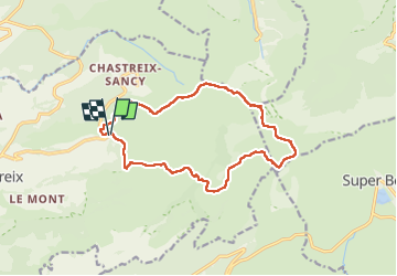

Length
14.7 km

Max alt
1862 m

Uphill gradient
694 m
Km-Effort
24 km

Min alt
1281 m

Downhill gradient
702 m
Boucle
Yes
Creation date :
2024-06-05 07:19:57.49
Updated on :
2024-06-06 07:08:17.199
7h24
Difficulty : Very difficult

FREE GPS app for hiking
 SityTrail
IGN / Geographical institutes
SityTrail Plus
The world is yours!
About
Trail Walking of 14.7 km to be discovered at Auvergne-Rhône-Alpes, Puy-de-Dôme, Chastreix. This trail is proposed by CABERMAT.
Positioning
Country:
France
Region :
Auvergne-Rhône-Alpes
Department/Province :
Puy-de-Dôme
Municipality :
Chastreix
Location:
Unknown
Start:(Dec)
Start:(UTM)
482127 ; 5040903 (31T) N.
Comments