Puy Pariou

Gegetop
User
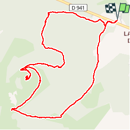

Length
6.8 km

Max alt
1178 m

Uphill gradient
249 m
Km-Effort
10.1 km

Min alt
967 m

Downhill gradient
249 m
Boucle
Yes
Creation date :
2015-04-15 00:00:00.0
Updated on :
2018-08-20 07:36:16.688
2h00
Difficulty : Easy

FREE GPS app for hiking
 SityTrail
IGN / Geographical institutes
SityTrail Plus
The world is yours!
About
Trail Walking of 6.8 km to be discovered at Auvergne-Rhône-Alpes, Puy-de-Dôme, Orcines. This trail is proposed by Gegetop.
Positioning
Country:
France
Region :
Auvergne-Rhône-Alpes
Department/Province :
Puy-de-Dôme
Municipality :
Orcines
Location:
Unknown
Start:(Dec)
Start:(UTM)
498981 ; 5072259 (31T) N.
Comments