


autour de Menet

CABERMAT
User
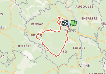

Length
14.3 km

Max alt
905 m

Uphill gradient
457 m
Km-Effort
20 km

Min alt
663 m

Downhill gradient
456 m
Boucle
Yes
Creation date :
2024-06-07 07:16:54.833
Updated on :
2024-06-07 12:38:55.732
5h20
Difficulty : Very difficult

FREE GPS app for hiking
 SityTrail
IGN / Geographical institutes
SityTrail Plus
The world is yours!
About
Trail Walking of 14.3 km to be discovered at Auvergne-Rhône-Alpes, Cantal, Menet. This trail is proposed by CABERMAT.
Photos

Positioning
Country:
France
Region :
Auvergne-Rhône-Alpes
Department/Province :
Cantal
Municipality :
Menet
Location:
Unknown
Start:(Dec)
Start:(UTM)
467431 ; 5015971 (31T) N.
Comments