


vauvert Est

leroj73
User
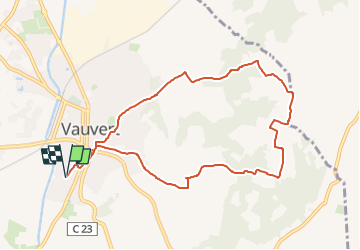

Length
9.8 km

Max alt
95 m

Uphill gradient
119 m
Km-Effort
11.4 km

Min alt
24 m

Downhill gradient
119 m
Boucle
Yes
Creation date :
2024-06-08 11:57:32.185
Updated on :
2024-06-08 11:58:39.568
2h34
Difficulty : Medium

FREE GPS app for hiking
 SityTrail
IGN / Geographical institutes
SityTrail Plus
The world is yours!
About
Trail Walking of 9.8 km to be discovered at Occitania, Gard, Vauvert. This trail is proposed by leroj73.
Description
Est de Vauvert sur les plateau de vignes
Positioning
Country:
France
Region :
Occitania
Department/Province :
Gard
Municipality :
Vauvert
Location:
Unknown
Start:(Dec)
Start:(UTM)
602469 ; 4837822 (31T) N.
Comments