


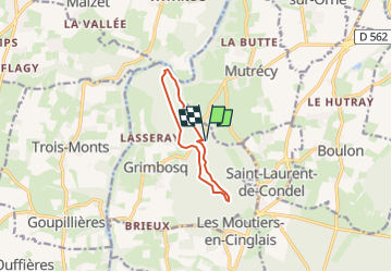
Forêt de Grimboscq chene Guillot

gr1346
User

Length
7.8 km

Max alt
118 m

Uphill gradient
108 m
Km-Effort
9.2 km

Min alt
21 m

Downhill gradient
108 m
Boucle
Yes
Creation date :
2024-06-09 10:09:32.648
Updated on :
2024-06-09 10:10:56.159
2h06
Difficulty : Medium

FREE GPS app for hiking
 SityTrail
IGN / Geographical institutes
SityTrail Plus
The world is yours!
About
Trail Walking of 7.8 km to be discovered at Normandy, Calvados, Grimbosq. This trail is proposed by gr1346.
Positioning
Country:
France
Region :
Normandy
Department/Province :
Calvados
Municipality :
Grimbosq
Location:
Unknown
Start:(Dec)
Start:(UTM)
687422 ; 5436141 (30U) N.
Comments