


Haliru - Ban de Laviot

albert318
User
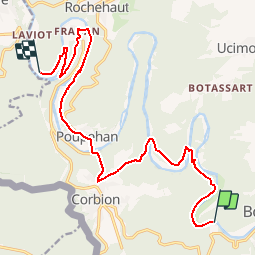

Length
15 km

Max alt
362 m

Uphill gradient
469 m
Km-Effort
21 km

Min alt
193 m

Downhill gradient
487 m
Boucle
No
Creation date :
2015-04-16 00:00:00.0
Updated on :
2015-04-16 00:00:00.0
4h30
Difficulty : Easy

FREE GPS app for hiking
 SityTrail
IGN / Geographical institutes
SityTrail Plus
The world is yours!
About
Trail Walking of 15 km to be discovered at Wallonia, Luxembourg, Bouillon. This trail is proposed by albert318.
Positioning
Country:
Belgium
Region :
Wallonia
Department/Province :
Luxembourg
Municipality :
Bouillon
Location:
Corbion
Start:(Dec)
Start:(UTM)
647369 ; 5517568 (31U) N.
Comments